


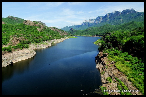
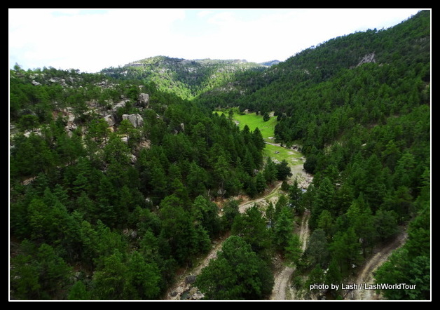
beautiful scenery near entrance to Copper Canyon
The Famous Copper Canyon – Mexico
Mexico’s astounding Copper Canyon is located in the northwestern states of Sinaloa and Chihuahua. If you haven’t heard of it before, this might astound you – Copper Canyon is four times bigger and two times deeper than Arizona’s Grand Canyon! I kid you not.
It’s actually a vast region in the Sierra Madre Occidental Mountains, comprised of six major interconnected canyons plus smaller canyons, shallow valleys, low rolling hills, pine-clad mountains, rock outcroppings and cliffs.
Six major rivers have carved the main canyons. They all flow into Fuerte River which then flows westward, emptying into the Sea of Cortez (also called Gulf of California) on the inland side of the long Baja Peninsula.
The Copper Canyon region varies in elevation between 100 M (330 ft) in the very bottom of the canyons to 2400 M (7920 ft) on top of the canyon rims.
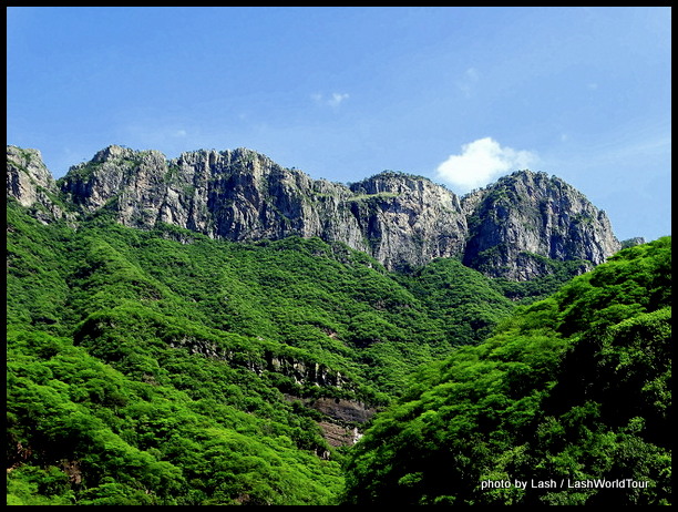 With such differing elevations, it’s not surprising that the area includes several distinct climate and vegetation zones. In the high elevations the area is covered by dense pine forests and it snows in winter.
Middle elevations are covered in oak and poplar forests. The bottom of the canyons, with elevations between 100-300 M are hot and humid year round.
At some places right in the middle of this vast region, deep canyons give way to soft rolling hills with pasture lands, vegetable & fruit farms and low tree-covered hills, meandering streams, lakes and waterfalls
There are several small towns, villages and scattered solitary houses throughout the area. Most are accessed by roads, some by the train line.
On the other hand, although people live within the canyon system, much of it is still very remote, rugged and difficult to access.
Copper Canyon is protected as a National Park. It also has UNESCO World Heritage status as of 19… Creel town, at a high point on the main canyon rim, is a Pueblo Magico ‘magic village’.
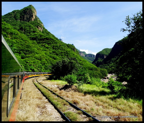
some dramatic scenery along El Chepe route
Access to Copper Canyon and El Chepe Train
Copper Canyon Nat. Park is accessed by both roads and a famous historic train called El Chepe (Ferrocarrill Chihuahua Pacifico). El Chepe is considered one of the world’s greatest train rides, both for the route’s amazing engineering feats and the stunning panoramic views.
The train runs in a northeastern/southwestern direction for 653 km (405 miles), primarily following the main canyon, called Urique. The tracks run between the cities of Chihuahua in the northeast and Los Mochis at the Pacific coast in Sinaloa.
Not surprisingly, most people visit Copper Canyon on this fantastic historic train. I wrote all about El Chepe in this article.
As just mentioned, there are also roads accessing some of the canyon regions. And for many places, especially in the deep canyon areas, roads are the only access. Buses run regularly on a daily basis from Chihuahua.
Copper canyon has become a major tourist destination for both Mexicans and international visitors. A few main towns and look-out points along the canyon rim as well as a few villages deep inside the canyons are set up for visitors, providing hotels and outdoor activities in the rugged terrain. (see more below)
 Brief History of Copper Canyon
The vast canyon system has been inhabited by indigenous Indian tribes for thousands of years. The most well-known tribe is the Raramuri (also called Tarahumata) who still live in the canyons.
In the early 1600s the Spanish discovered silver, gold and other precious minerals in the Copper Canyon. By 1632 they had set up Batopilas town and nearby mines in the very bottom of the canyons. The mine owners quickly enslaved the peaceful Raramuri to work the mines and continued mining operations for over two centuries.
Today some mining operations are still functioning. Other industries include logging, farming by Raramuri and, most recently, tourism.
In more recent history, Mennonites from USA migrated to Copper Canyon in 1922 and set up farms. They thrive to this day and now produce huge quantities of quality cheeses and dairy products.
They’re centered around the little city of Cuauhtemoc in the eastern end of the canyon region and are now the largest Mennonite settlement in the world with over 48,000 people!
Visitors can visit Cuauhtemoc , a museum about the Mennonites and some Mennonite farms in the area.
The full length of El Chepe Train opened in 1961, making access to Copper Canyon considerably easier for both travelers and freight cargo.
Since then the region has gradually become one of Mexico’s most famous tourist destinations. Since about 2010 it has really taken off as a popular destination for outdoor adventures, the historic train journey and appreciating the stunning scenery.
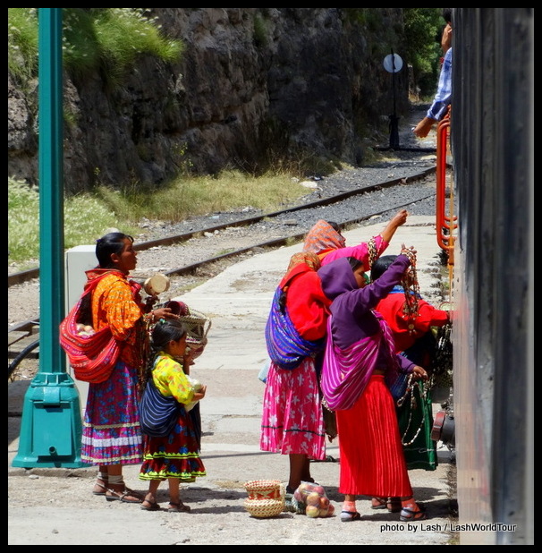
Raramuri women meeting El Chepe to sell handicrafts
Raramuri Tribe in Copper Canyon
Raramuri are traditionally quite peaceful, preferring to live off the land in a sustainable fashion. Most still choose to live as far away from civilization as possible, living off the land and traveling on foot. In the vast rugged Copper Canyon, they’re able to stay secluded so to some extent.
Raramuri are famous internationally for their astounding long-distance running abilities and have participated in ultra-long marathons around the world. There’s also an annual marathon in Copper Canyon.
They also make beautiful, vibrant clothing and fabrics, ceramics and baskets. Nowadays some Raramuris sell these products to visitors, particularly those riding El Chepe.
Visitors to Copper Canyon will probably see – and interact with – these Indians at particular points along the train journey, including Santa Rosa, Divisidero, Creel, Cahuito and Baho.
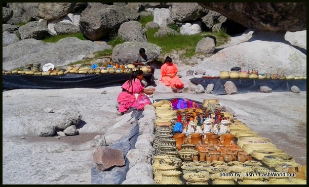
Raramuri girls selling handicrafts in a valley near Creel
At the village of Santa Rosa, for instance, local women, girls and boys, dressed in their colorful traditional clothing, rush to the train as it pauses in town for 10-20 minutes. They’re eager to sell bags of locally-grown apples and colorful, hand-woven baskets & boxes.
At Divisidero train station, they’ve set up a huge souvenir and food market at the platform. Local women are busy grilling ‘gorditas’ – tortilla pockets filled with potatoes or beans or meat and other local specialties. Souvenir stands are full of colorful baskets, clothing and various trinkets.
In addition, some Raramuris are likely to be riding El Chepe to/from their homes and the big outside cities of Los Mochis, El Fuerte or Chihuahua.
The largest population of Raramuri live in and near Creel, a major (but still small) town situated on top of the canyons and along the train line. Visitors will see them wearing their traditional clothing walking the streets, selling their handicrafts, running shops and restaurants and food stalls.
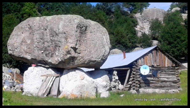
Raramuri log home in valley near Creel
While some Raramuri live in rather modern villages and towns like Creel, in houses constructed of brick/cement with corrugated metal roofs. The more secluded people still live in caves deep in the remote canyons and near Lake Ararareca.
Others live in individual houses or clusters of houses, scattered throughout the canyons. For instance, I saw dozens of individual Raramuri houses out in the canyons near Creel.
Their small homes include log cabins, stone houses, cement block homes and more modern, brightly painted houses. Many cook by wood fires. They grow vegetables, raise cows and sell handicrafts to visiting tourists.
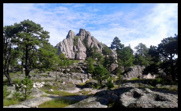
beautiful rock formations near Creel
Things to See And Do in Copper Canyon
The vast Copper Canyon are filled with all sorts of outdoor adventures and activities. Visitors can go hiking, rock climbing, rappelling, off-road cycling, ATV-ing, horseback riding and kayaking on Lake Arareca. There’s also an outdoor ‘adventure park’ offering zip-lining, a cable car and other activities.
Travelers can visit various rock outcroppings, caves, Lake Arareca, some of Mexico’s highest waterfalls and cliffs, as well as Raramuri villages, Mennonite farms and historic Jesuit Missions.
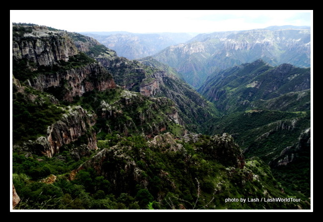
view of Urique CAnyon from Divisidero
Main Places to Visit in Copper Canyon
The main places to visit along the train route include Creel and Divisidero, situated on top of the canyon rim and Batopilas, Urique, Cahuu deep within the main canyons. More intrepid travelers can also explore more remote, less visited areas.
On top of the canyon system and along the train line
Divisidero – Divisidero is situated at one of the highest elevations along the train route and right on the edge of the main Urique Canyon. It’s actually the only point along the route where visitors can look down into the vast, sprawling canyon.
El Chepe stops at Divisdero for 15-20 minutes for passengers to take a peak. But they can also opt to stay over night at three luxury hotels perched on the edge of the canyon or at a couple less expensive places.
Also, as mentioned above, there’s a huge food and souvenir market at this station platform. Visitors can try tasty local food or buy some Raramuri handicrafts.
The adventure park is located nearby.
Creel – Creel is the primary place where visitors stay in Copper Canyon, whether they arrive by train, bus, tour group or their own vehicles. It’s situated at a very high elevation as well, but far from the canyon rim.
From Creel it’s easy to make many explorations into nearby valleys and canyons, to go cycling or horseback riding and to visit waterfalls and Lake Ararepo.
It’s a small, quaint town with many small hotels for all budgets, many eating options and tour companies. It’s also a Pueblo Magico, due to the large numbers of Raramuri living there.
Bahuichivo – Passengers on El Chepe disembark at this station in order to head down into the canyon to Cerocahui, Urique and Batopilas (detailed below).
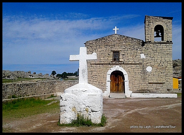
Mision near Creel
Deep in the canyons
Cerocahui – Cerocahui is located about 1 ½ hours down from Bahuichivo. It’s the site of a historic Jesuit Mision established in the 1500s and is set amidst beautiful canyon scenery. Besides visiting the quaint town and mision, travelers can look down into the canyon all the way to Urique.
Urique – Urique is a tiny village situated deep inside Urique Canyon, the region’s biggest and deepest. It’s a steep 3-hour trip down on a rough road from Bahuichivo. Once there visitors can enjoy the stunning scenery, hike, ride horses and witness daily lives of Raramuri.
Batopilas – As detailed above, Batopilas is situated at the very bottom of the main canyon at 500 M in elevation and was established by the Spanish in the 1600s because of the nearby mines.
Today visitors make the long, steep journey down to tiny Batopilas to experience the thrilling ride and the deep canyon scenery.
I’ll be writing about my own journey on El Chepe and week-long visit to Creel next. Stayed tuned for a first-hand account of this famous train ride and the stunning Copper Canyon.
Meanwhile, you might also want to read
El Fuerte – Historic Town I Sinaloa
============================


 Hi! I'm Lash, an American nomadic world traveler who's been traveling solo since 1998. I’m passionate about traveling the world nomadically and then sharing it all with you. I hope to inspire you to travel the world, to entertain you with tales from the road, and to help you reach your travel dreams. Welcome!